
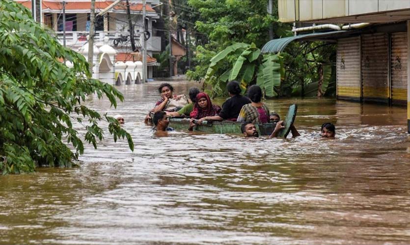
For the past four years, Kerala has been witnessing the disastrous wrath of unending rains way past its monsoons, resulting in extreme weather conditions, and ending up with escalating casualties and property losses. The recent cloudburst in Kerala has resulted in catastrophic damages mostly across the southern part of the state. The unseasonal heavy downpour this year has affected Kottayam, Ernakulam, Idukki, Alleppey and Pathanamthitta districts, killing at least 26 and rendering many homeless. The India Meteorological Department (IMD) explains the rains as a result of two low pressure regions developed in the Arabian Sea due to an influx of surface temperature on the sea. Many experts point to the critical weather as a response to increasing illegal constructions and land use in sensitive regions, including different regions of the Western Ghats. Regardless of these conclusions, the effects of unseasonal rains and the unpredictable weather has had a great role in wreaking havoc in the state.
According to the IMD, the peak monsoon season of Kerala is between June 1 and September 30, mainly called the southwest monsoons. By the end of September the rains show a steady decline. The withdrawal of the southwest monsoon signals the arrival of the northeast monsoon powered by the northeasterly winds to peninsular Andhra Pradesh and Tamil Nadu. Accordingly, there used to be an average of two to three cyclone storms forming in the Arabian Sea both pre-monsoon and post-monsoon season every year, mainly due to the temperature above the surface of the Arabian Sea. Comparatively, the sea surface is 1.5 percent to 2 percent lower over the Bay of Bengal, leading to fewer cyclones.
Usually there is a two week gap between two seasons. The decline of the southwest monsoon for 2021 hasn’t been announced by the IMD yet. According to a study conducted by the Indian Institute of Tropical Meteorology (IITM) and the Union Ministry of Earth Sciences, there has been an increase of 52 percent in the frequency of cyclones in the Arabian Sea, between 2001 and 2019, whereas only a hike of 8 percent has been seen in the Bay of Bengal. The intensity of the 2018 Kerala Mega flood was noteworthy. Out of the seven cyclones formed in the Indian Ocean, three had generated from the Arabian Sea. The same was witnessed during the 2019 floods, when there were eight cyclones, five of which initiated in the Arabian Sea. These statistics when compared with 1960-1970 show a different picture as the Bay of Bengal signaled 135 cyclones and the Arabian Sea experienced only 23 at the time.
These statistics can set a direct link with climate change and the uneven and unprecedented rains experienced by the state. It calls for the state government to take long term actions instead of merely cleaning up on the surface level. The recently published Intergovernmental Panel on Climate Change (IPCC) reports has put Kerala in the most vulnerable position for climate change. The state will be the most affected as a result of climate change. According to the sea level projection tool prepared by NASA, based on indicators provided by the IPCC, by 2030, the sea level rise will witness an increase of 0.11m; 0.71m by 2100; and by 2150 it will reach 1.24m. By 2030, the total rise of the sea level will supposedly take over a total of 374 sq. kms., of which, 150 sq. kms. will be in Thrissur, 116 sq. kms. in Alleppey, 88 sq. kms. in Kottayam and 20 sq. kms. in Ernakulam. The report focuses on the result of climate change leading to events like heat waves, droughts, floods and landslides in the 21st century. The extreme climatic situations that are witnessed only once every 100 years may start occurring more frequently by the end of the century.
Kerala is considered as the most vulnerable due to its coast line and high population. The frequent disastrous events will end up being a threat to agricultural practices, and also put the biodiversity in jeopardy. The state government, in 2014, has proposed a Kerala state action plan for climate change. The plan was revised in 2019 after the second flood. The document focused on migrant workers, health, water and energy. It also highlighted the effects on the farmers, fishermen and the tribal population who are most vulnerable to climate change. The report also marked major climate change hotspot districts such as Alappuzha, Palakkad, and the hilly areas of Wayanad and Idukki. Regardless of these revisions, environmentalists claim that the state government hasn’t done anything to address the issues of climate change, and that no proper discourse was conducted with the public regarding the revised report. Environmentalist Sunitha Narian says, “The state has to focus more on better management of water, dams and Western Ghats. Quarrying and other activities happening in the Western Ghats should be stopped. Also plans for drainage recharging should be focused, since recharging water is the key to avoid droughts that’s experienced after the floods.”
Read more: US, EU Plan To Cut Methane Emissions By 30 Percent, By 2030
Long term mitigation plans instead of short rehabilitation and rescue are the need of the hour. Better water management should be practiced and improved efficiency in rain forecasting is necessary to predict extreme cloudburst situations. The state should indulge in fair and transparent environmental impact assessments for large infrastructure projects. Vulnerable coastal areas should be introduced to climate resilient coastal development. Proper and effective revision of the Kerala state action plan on climate change, adopting more mitigation measures, and raising social awareness based on scientific principles are some of the essential ways forward.